Bria, Central African Republic
Bria | |
|---|---|
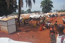
 Refugees camp in PK3, Bria | |
| Coordinates: 6°32′13″N 21°59′31″E / 6.53694°N 21.99194°E | |
| Country | Central African Republic |
| Prefecture | Haute-Kotto |
| Government | |
| • Sub-Prefect | Brahim Abdoulaye[1] |
| • Mayor | Maurice Balekouzou |
| Elevation | 553 m (1,814 ft) |
| Population (2012) | |
| • Total | 43,322 |
| • Ethnicities | Goula Peuhl |
Bria is the capital of Haute-Kotto, one of the 14 prefectures of the Central African Republic. As of the 2003 census the town had a population of 35,204.
Geography
[edit]Bria is located on the Kotto River.
History
[edit]In 1930, a ginning factory was established in Bria by the Comouna cotton company.
Civil war
[edit]


On 18 December 2012 Bria was captured by Séléka rebels.[2] On 21 November 2016 an armed conflict broke out between the ethnicities Gula and Peuhl representing different armed groups resulting in death of 92 people, many more injured and 12000 refugees around the UN camp outside the city.
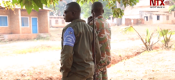
On 18 May 2017 heavy clashes erupted between Anti-balaka and ex-Seleka in Bria resulting in 26 deaths.[3] On 21 June 2017 clashes between rival factions resulting in death of around 100 people.[4] On 4 December 2017 Anti-balaka fighters led by Jean-Francis Diandi attacked international forces in Bria killing one Mauritanian peacekeeper.[5] On 16 March 2018 Jean-Francis Diandi was arrested by peacekeepers.[6] On 6 September 2018 Séléka rebels killed a number of people, most of them women.[7][8]
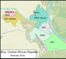
On 25–6 January 2020 MLCJ attacked Bria capturing more than 60% of the city after 24 hours of clashes with FPRC.[9] On 28 January both groups signed ceasefire promising to withdraw fighters from parts of the town.[10] On 22 March 2021 Bria was recaptured by government forces.[11] One FPRC fighter was killed.[12] On 2 April rebels launched attack on Bria which was repelled, two rebels and one soldier were killed.[13]
Since 15 December 2021, Russian mercenaries from the Wagner Group have arrested numerous people – mainly youths – inside the town, leading to reported human rights abuses. On 4 January, the Wagner Group gunned down young people in a massacre. At 5:00 P.M. mercenaries entered the local mosque and removed the corpses of their victims from the building.[14][15]
Climate
[edit]Bria has a tropical savanna climate (Köppen climate classification Aw), with a lengthy though not intense wet season from mid-March to October and a relatively short and mostly rainless dry season from November to mid-March. Although the wet season is longer than the dry season, the dry season is sufficiently dry and the wet season insufficiently wet for tropical monsoon classification.[citation needed]
| Climate data for Bria | |||||||||||||
|---|---|---|---|---|---|---|---|---|---|---|---|---|---|
| Month | Jan | Feb | Mar | Apr | May | Jun | Jul | Aug | Sep | Oct | Nov | Dec | Year |
| Mean daily maximum °C (°F) | 34.6 (94.3) |
36.8 (98.2) |
36.9 (98.4) |
34.7 (94.5) |
32.9 (91.2) |
31.3 (88.3) |
30.7 (87.3) |
30.3 (86.5) |
31.3 (88.3) |
31.8 (89.2) |
32.2 (90.0) |
33.6 (92.5) |
33.1 (91.6) |
| Daily mean °C (°F) | 24.5 (76.1) |
27.6 (81.7) |
28.2 (82.8) |
28.0 (82.4) |
27.3 (81.1) |
25.9 (78.6) |
25.5 (77.9) |
25.1 (77.2) |
25.7 (78.3) |
25.9 (78.6) |
25.4 (77.7) |
24.2 (75.6) |
26.1 (79.0) |
| Mean daily minimum °C (°F) | 14.5 (58.1) |
17.9 (64.2) |
19.7 (67.5) |
21.5 (70.7) |
21.0 (69.8) |
20.5 (68.9) |
20.2 (68.4) |
20.2 (68.4) |
20.1 (68.2) |
19.9 (67.8) |
18.1 (64.6) |
15.3 (59.5) |
19.1 (66.3) |
| Average rainfall mm (inches) | 8 (0.3) |
12 (0.5) |
60 (2.4) |
108 (4.3) |
174 (6.9) |
174 (6.9) |
219 (8.6) |
230 (9.1) |
232 (9.1) |
195 (7.7) |
28 (1.1) |
2 (0.1) |
1,442 (57) |
| Source 1: Normales et records pour la période 2000-2012 à Bria ,[16] | |||||||||||||
| Source 2: Climate Bria - Central African Republic for rainfall totals ,[17] | |||||||||||||
Infrastructure
[edit]See also
[edit]References
[edit]- ^ Oubangui Medias, Oubangui Medias. "Centrafrique : Décrets portant nomination des Gouverneurs, des Préfets et des Sous-Préfets". oubanguimedias.com. Oubangui Medias. Retrieved 6 June 2024.
- ^ "Central African Republic rebels take diamond-mine town". 18 December 2012.
- ^ CAR: Clashes break out in Bria (northeast) May 18-19
- ^ "'Around 100 killed' in CAR's Bria despite truce deal". aljazeera.com. 21 June 2017. Retrieved 18 December 2018.
- ^ Leader Of Anti-Balaka Militia In Central Africa Republic Arrested By UN Peacekeepers, 22 March 2018
- ^ RCA : Ramazani, le chef milicien Anti-Balaka de Bria, libéré de Ngaragba, rejoint le CPC, 17 March 2021
- ^ "UN police investigating killing of displaced people in Central African Republic". news.un.org. 7 September 2018. Retrieved 18 December 2018.
- ^ "Central African Republic: Rebels Executing Civilians". hrw.org. 12 October 2018. Retrieved 18 December 2018.
- ^ "Bria, le MLCJ contrôle 60% de la ville, des dizaines des habitations incendiées". 27 January 2020.
- ^ RCA : un accord de cessez-le-feu à Bria, les groupes armés s’engagent à retirer leurs troupes, 28 January 2020
- ^ Félicitations à nos militaires et aux alliés qui ont pris le contrôle de Bria, chef lieu de la Prefecture de la Haute Kotto., Ngrebada Firmin, 22 March 2021
- ^ RCA : retour au calme à Bria après une journée de tension, 22 March 2021
- ^ RCA : violente attaque des positions des soldats FACA à l’entrée de Bria par les rebelles du CPC, 2 April 2021
- ^ Munshi, Neil; Seddon, Max (22 October 2021). "Russian mercenaries leave trail of destruction in the Central African Republic". Financial Times. Retrieved 5 January 2022.
- ^ "Russian Mercenaries Kill 4 Civilians In Central African Republic". HumAngle Media. 5 January 2022. Retrieved 5 January 2022.
- ^ "Normales et records pour la période 2000-2012 à Bria". Infoclimat. Retrieved 13 January 2014.
- ^ "Climate Bria - Central African Republic for rainfall totals". Infoclimat. Archived from the original on 24 October 2015. Retrieved 13 January 2014.


