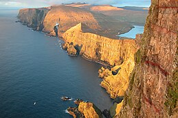
List of islands of the Faroe Islands
Appearance
Native name: Føroyar | |
|---|---|
 | |
 | |
| Geography | |
| Location | Norwegian Sea, Atlantic Ocean |
| Coordinates | 62°00′N 06°47′W / 62.000°N 6.783°W |
| Archipelago | Faroe Islands |
| Total islands | 18 |
| Major islands | Streymoy, Eysturoy, Vágar, Suðuroy |
| Area | 1,399 km2 (540 sq mi) |
| Highest elevation | 882 m (2894 ft) |
| Highest point | Slættaratindur |
| Administration | |
Faroe Islands | |
| Largest settlement | Tórshavn (pop. 12,393) |
| Demographics | |
| Population | 50,235 (7-2017) |
| Ethnic groups | Faroese, Danish |
This is a list of islands of the Faroe Islands. There are 18 islands, of which Lítla Dímun is the only one uninhabited. Besides these 18 islands there are also several islets and skerries in the Faroes.
| Name | Area [km2][1] | Population (12-2018)[2] | Population density [inhabitants/km2] | Main settlements | Sýsla (District) |
|---|---|---|---|---|---|
| Streymoy | 373.5 | 24,276 | 65.0 | Tórshavn and Vestmanna | Streymoy |
| Eysturoy | 286.3 | 11,490 | 40.1 | Fuglafjørður and Runavík | Eysturoy |
| Vágar | 177.6 | 3,271 | 18.4 | Míðvágur and Sørvágur | Vágar |
| Suðuroy | 166.0 | 4,588 | 27.6 | Tvøroyri and Vágur | Suðuroy |
| Sandoy | 112.1 | 1,231 | 11.0 | Sandur | Sandoy |
| Borðoy | 95.0 | 5,261 | 55.4 | Klaksvík | Norðoyar |
| Viðoy | 41.0 | 605 | 14.8 | Viðareiði | Norðoyar |
| Kunoy | 35.5 | 146 | 4.1 | Kunoy | Norðoyar |
| Kalsoy | 30.9 | 76 | 2.5 | Mikladalur and Húsar | Norðoyar |
| Svínoy | 27.4 | 26 | 0.9 | Svínoy | Norðoyar |
| Fugloy | 11.0 | 37 | 3.4 | Kirkja | Norðoyar |
| Nólsoy | 10.3 | 227 | 22.0 | Nólsoy | Streymoy |
| Mykines | 10.3 | 14 | 1.4 | Mykines | Vágar |
| Skúvoy | 10.0 | 33 | 3.3 | Skúvoy | Sandoy |
| Hestur | 6.1 | 20 | 3.3 | Hestur | Streymoy |
| Stóra Dímun | 2.7 | 10 | 3.7 | Dímun | Sandoy |
| Koltur | 2.5 | 1 | 0.4 | Koltur | Streymoy |
| Lítla Dímun | 0.8 | 0 | 0 | – | Suðuroy |
| Total | 1,396 | 51,312 | Ø 36.8 |
See also
[edit]References
[edit]- ^ Statistics Faroe Islands, Faroe Islands in figures 2012, Argir 2012, ISSN 1603-8479, S. 7 (PDF)
- ^ Επίσημη εκτίμηση

